
Warming Trend, Then Unsettled Pattern by Midweek

NORTH ALABAMA:
(Forecast)
Sunday (High 70, Low 43): Sunny. Breezy.
Monday (High 76, Low 54): Partly cloudy. Breezy.
Tuesday (High 83, Low 61): Partly cloudy and breezy. Isolated showers/thunderstorms are possible, mainly at night.
(Extended Outlook)
Wednesday (High 80, Low 63): Mostly cloudy with a 50% chance of showers/thunderstorms.
Thursday (High 77, Low 62): Mostly cloudy with a 50% chance of showers/thunderstorms.
Friday (High 79, Low 61): Partly cloudy with a 40% chance of showers/thunderstorms.
Saturday (High 78, Low 62): Partly to mostly cloudy with a 40% chance of showers/thunderstorms.
SOUTHERN MIDDLE TENNESSEE:
(Forecast)
Sunday (High 69, Low 41): Sunny. Breezy.
Monday (High 75, Low 53): Partly cloudy. Breezy.
Tuesday (High 80, Low 59): Partly cloudy and breezy. Isolated showers and thunderstorms are possible, mainly at night.
(Extended Outlook)
Wednesday (High 78, Low 62): Mostly cloudy with a 50% chance of showers/thunderstorms.
Thursday (High 74, Low 58): Mostly cloudy with a 50% chance of showers/thunderstorms.
Friday (High 76, Low 60): Partly cloudy with a 40% chance of showers/thunderstorms.
Saturday (High 78, Low 61): Partly cloudy with a 40% chance of showers/thunderstorms.
DOWN AT THE BEACH:
Sunday (High 72, Low 57): Mostly sunny and breezy. Dangerous rip currents.
Monday (High 77, Low 61): Partly cloudy and breezy. Dangerous rip currents.
Tuesday (High 78, Low 64): Partly cloudy. Isolated showers and thunderstorms are possible, mainly during the afternoon and evening.
Wednesday through Saturday (Highs in the upper 70’s, Lows in the mid-60’s): Partly to mostly cloudy with a 40% chance of scattered showers and thunderstorms.
NORTE DE ALABAMA:
(Pronóstico)
Domingo (Máx. 70, Mín. 43): Soleado. Ventoso.
Lunes (Máx. 76, Mín. 54): Parcialmente nublado. Ventoso.
Martes (Máx. 83, Mín. 61): Parcialmente nublado y ventoso. Son posibles lluvias o tormentas aisladas, principalmente por la noche.
(Pronóstico Extendido)
Miércoles (Máx. 80, Mín. 63): Mayormente nublado, con un 50% de probabilidad de lluvias y tormentas.
Jueves (Máx. 77, Mín. 62): Mayormente nublado, con un 50% de probabilidad de lluvias y tormentas.
Viernes (Máx. 79, Mín. 61): Parcialmente nublado, con un 40% de probabilidad de lluvias y tormentas.
Sábado (Máx. 78, Mín. 62): De parcialmente a mayormente nublado, con un 40% de probabilidad de lluvias y tormentas.
SUR DEL CENTRO DE TENNESSEE:
(Pronóstico)
Domingo (Máx. 69, Mín. 41): Soleado. Ventoso.
Lunes (Máx. 75, Mín. 53): Parcialmente nublado. Ventoso.
Martes (Máx. 80, Mín. 59): Parcialmente nublado y ventoso. Son posibles lluvias y tormentas aisladas, principalmente por la noche.
(Pronóstico Extendido)
Miércoles (Máx. 78, Mín. 62): Mayormente nublado, con un 50% de probabilidad de lluvias y tormentas.
Jueves (Máx. 74, Mín. 58): Mayormente nublado, con un 50% de probabilidad de lluvias y tormentas.
Viernes (Máx. 76, Mín. 60): Parcialmente nublado, con un 40% de probabilidad de lluvias y tormentas.
Sábado (Máx. 78, Mín. 61): Parcialmente nublado, con un 40% de probabilidad de lluvias y tormentas.
EN LA PLAYA:
Domingo (Máx. 72, Mín. 57): Mayormente soleado y ventoso. Peligrosas corrientes de resaca.
Lunes (Máx. 77, Mín. 61): Parcialmente nublado y ventoso. Peligrosas corrientes de resaca.
Martes (Máx. 78, Mín. 64): Parcialmente nublado. Son posibles lluvias y tormentas aisladas, principalmente durante la tarde y la noche.
De Miércoles a Sábado (Máximas en los 70 grados superiores, Mínimas en los 60 grados medios): De parcialmente a mayormente nublado, con un 40 % de probabilidad de lluvias y tormentas dispersas.
NOTES:
Most of us in the TN Valley remain under moderate drought conditions, so next week’s rain will be welcome.
If you were recently impacted by a tornado or by storms that made you concerned about a tornado, the National Severe Storms Laboratory would like to hear from you. If you can spare a few minutes to take their survey.
The Lawrenceburg NOAA Weather Radio transmitter remains offline indefinitely.
And that is because of the ice storm we had in January. The National Weather Service in Huntsville did an excellent job explaining that significant winter storm.
The National Weather Service in Nashville is doing Weather101 classes again.
Beachgoers may want to review how to stay safe in a rip current.
DISCUSSION:


At 5:50 PM CDT latest observations show fair skies in Cullman with a temperature of 64 degrees. The dewpoint is only 12 degrees, making the relative humidity 13%. Winds are from the East at 8 miles per hour. The pressure is 30.34 inches and steady.
Skies are fair with a temperature of 65 in Huntsville. The dewpoint is 22, making the relative humidity 19%. Winds are Northwest at 5 mph. The pressure is 30.34 inches/1027.5 millibars and falling slowly at the moment.
Then across the Tennessee line, in Winchester there in Franklin County, skies are fair with a temperature of 64 degrees. The dewpoint is 10 degrees, making the relative humidity 12%. Winds are Northeast at 13 mph. The pressure is 30.34 inches and steady.
And at Columbia in Maury County, skies are fair with a temperature of 61. The dewpoint is 16, making the relative humidity 17%. Winds are from the Northeast at 12 miles per hour. The pressure is 30.37 inches and steady.
We just had a cold front pass through yesterday with light, very isolated and spotty showers. Behind it, we’ve had windy conditions last night into this morning. (It blew my garbage can over outside, scared the bejesus out of the cats in the middle of the night.) And the air has been very dry. That’s why a red flag warning has been in effect to discourage people from burning things while it is this dry and windy. Fires can easily catch up on days like this.
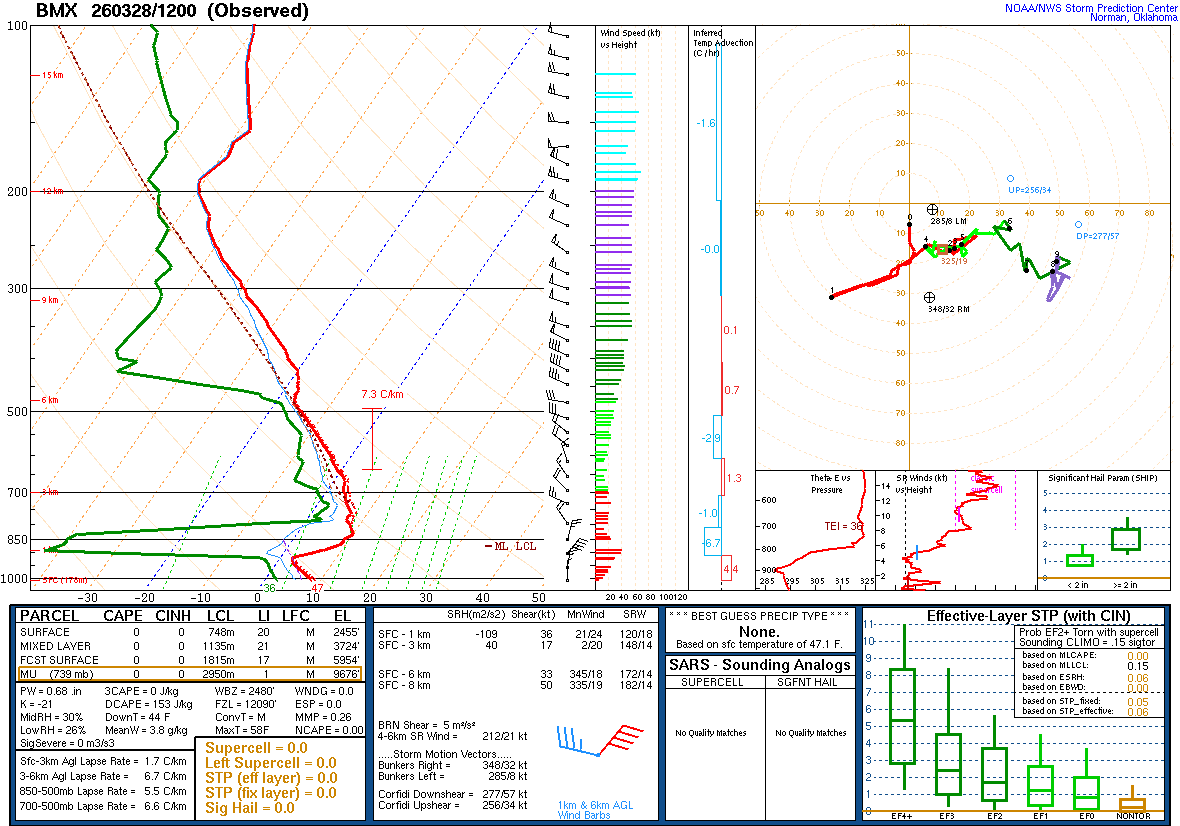
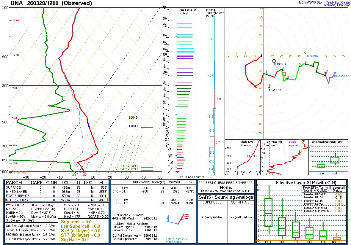
And right here as we’re getting into the peak of our severe weather season, we’ve lucked out at the moment, because this morning’s soundings from Birmingham and Nashville both showed a very stable airmass and no wind shear worth worrying about as far as feeding into any storms. Today is obviously the opposite of a stormy day, and yesterday was kind of strange for late March. To have a cold front come through this time of year with no chance for storms is fortunate indeed.


Tomorrow looks like another sunny, breezy day. Look for a High near 70, a Low near 43 for Huntsville.


By Monday we’ll have some decent West/Southwest wind flow allowing some Gulf moisture back in here. Skies will be partly cloudy, and it will still be kind of breezy. Look for a High in the range of about 75-78, a Low in about the range of 52-55.


Partly cloudy and breezy again on Tuesday, and I’ll bring back a 20% chance of rain here. The other global model guidance is in good enough agreement with the GFS that it feels reasonable. Look for a High in the lower 80’s, a Low of about 60 or so.


Then Wednesday, which is the first day of April, I’m trying not to let it make an April Fool out of any of us, cross-examining the global model data. And the rain chances have trended upward a bit. The Canadian is the outlier, with a slower progression of the rain along/ahead of the cold front. For now will forecast a mostly cloudy day, another breezy one, 50% chance of showers and thunderstorms. And look for a High near 80, Low in the lower 60’s.


Then Thursday, that front remains stalled, and we’re in an unsettled pattern. Will keep the chance of rain at 50%. Look for a High in the mid-to-upper-70’s and a Low near 60 or so.


Friday the front should start to make some slow progress through the region. The ECMWF shows it moving more gradually than the GFS, no surprise there.
Will trim the rain chance back to 40%. Expecting a High in the mid-to-upper-70’s, a Low in the lower 60’s.


But this system just isn’t making much progress even on Saturday. It is a stalled pattern where just when you think the thing is starting to move, it stalls out again.


Here’s how it looks on standard weather maps instead of raw model data. This front is just going to stay stalled and bring us rain chances each day from Tuesday on. The chance of rain is minimal Tuesday, probably holds off until at least Tuesday night for most of us. And by Saturday I’ll keep the chance of rain down at 40%. Highs should be in the upper 70’s, Lows in the lower 60’s.
The Storm Prediction Center has not outlooked any part of our region for severe thunderstorms, and nothing jumps out as a clear signal of any risk like that, despite the time of year it is. You always have to keep an eye on things this time of year, but overall this just looks like a soaker over several days’ time.


And the rainfall estimates have come up quite a bit from the Weather Prediction Center. We could see anywhere from 1.5-2.5 inches of average rainfall over the next seven days in North Alabama and Southern Middle Tennessee. And we do need the rain. Not every weather forecast has to be laden with great drama. Sometimes it comes back to basics. Like the old saying: April showers bring May flowers.