
Sunshine Returns Through the Weekend with a Cold Snap Tomorrow/Rain Returns Sunday Night with Even Colder Air Behind It

NORTH ALABAMA:
(Forecast)
Thursday (High 56, Low 42): Mostly sunny. Cold and breezy.
Friday (High 67, Low 36): Sunny. Cool and breezy.
Saturday (High 75, Low 43): Sunny. Mild.
(Extended Outlook)
Sunday (High 76, Low 52): Mostly sunny during the day, showers and thunderstorms likely at night.
Monday (High 50, Low 40): Partly sunny with a 20% chance of showers.
Tuesday (High 48, Low 27): Mostly sunny.
Wednesday (High 60, Low 32): Partly to mostly sunny.
SOUTHERN MIDDLE TENNESSEE:
(Forecast)
Thursday (High 56, Low 38): Mostly sunny. Cold and breezy.
Friday (High 66, Low 35): Sunny. Cool and breezy.
Saturday (High 73, Low 40): Sunny.
(Extended Outlook)
Sunday (High 76, Low 52): Mostly sunny during the day, showers and thunderstorms likely at night.
Monday (High 46, Low 35): Partly sunny with a 20% chance of showers.
Tuesday (High 47, Low 23): Sunny.
Wednesday (High 60, Low 30): Partly to mostly sunny.
DOWN AT THE BEACH:
Thursday (High 68, Low 54): Widely scattered showers lingering in the morning. Becoming sunny and breezy in the afternoon - but still with dangerous rip currents.
Friday (High 70, Low 45): Sunny.
Saturday (High 74, Low 53): Sunny.
Sunday (High 77, Low 61): Mostly sunny with a 20% chance of isolated showers and thunderstorms.
NORTE DE ALABAMA:
(Pronóstico)
Jueves (Máx. 56, Mín. 42): Mayormente soleado. Frío y ventoso.
Viernes (Máx. 67, Mín. 36): Soleado. Fresco y ventoso.
Sábado (Máx. 75, Mín. 43): Soleado. Templado.
(Pronóstico Extendido)
Domingo (Máx. 76, Mín. 52): Mayormente soleado durante el día; probables lluvias y tormentas eléctricas por la noche.
Lunes (Máx. 50, Mín. 40): Parcialmente soleado, con un 20% de probabilidad de lluvias.
Martes (Máx. 48, Mín. 27): Mayormente soleado.
Miércoles (Máx. 60, Mín. 32): De parcialmente a mayormente soleado.
SUR DEL CENTRO DE TENNESSEE:
(Pronóstico)
Jueves (Máx. 56, Mín. 38): Mayormente soleado. Frío y ventoso.
Viernes (Máx. 66, Mín. 35): Soleado. Fresco y ventoso.
Sábado (Máx. 73, Mín. 40): Soleado.
(Pronóstico Extendido)
Domingo (Máx. 76, Mín. 52): Mayormente soleado durante el día; probables lluvias y tormentas eléctricas por la noche.
Lunes (Máx. 46, Mín. 35): Parcialmente soleado, con un 20% de probabilidad de lluvias.
Martes (Máx. 47, Mín. 23): Soleado.
Miércoles (Máx. 60, Mín. 30): De parcialmente a mayormente soleado.
EN LA PLAYA:
Jueves (Máx. 68, Mín. 54): Lluvias muy dispersas que persistirán durante la mañana. El tiempo pasará a ser soleado y ventoso por la tarde, aunque persistirán las peligrosas corrientes de resaca.
Viernes (Máx. 70, Mín. 45): Soleado.
Sábado (Máx. 74, Mín. 53): Soleado.
Domingo (Máx. 77, Mín. 61): Mayormente soleado, con un 20 % de probabilidad de lluvias y tormentas aisladas.
NOTES:
The National Weather Service offices in Huntsville and Birmingham have put together (or at least linked to) pages about Monday March 9’s severe weather in the region.
NWS Birmingham still has a couple SKYWARN classes left that you can take online if you weren’t able to make it to a physical class this year.
NWS Nashville has started their Weather101 classes back up for this season.
And for anyone headed to the beach this month, here are some reminders about staying safe in rip currents.
DISCUSSION:
At 6:35 PM CDT, light rain is falling in Cullman. The temperature is 63 degrees. The dewpoint is also 63, making the relative humidity 100%. Winds are variable at 3 miles per hour. The pressure is 29.98 inches and waffling up and down. The visibility is 9 miles.
It is mostly cloudy and 72 degrees in Jasper. The dewpoint is 66, making the relative humidity 83%. Winds are variable at 6 mph. The pressure is 29.95 inches and rising. The visibility is 10 miles.
Huntsville is overcast and 67 degrees. The dewpoint is 60, making the relative humidity 79%. Winds are Northwest at 3 mph. The pressure is 29.95 inches/1013.7 millibars and rising. The visibility is 10 miles.
Winchester is overcast and 63 degrees. Ditto dewpoint, so 100% RH. Winds East at 5. Pressure is 29.96 inches and steady. Visibility 10 miles.
Fayetteville is overcast and 66 degrees. The dewpoint is 61 degrees, making the relative humidity 83%. Winds are West at 8 mph. The pressure is 29.96 inches and steady. Visibility 10 miles.
Murfreesboro is overcast and 66 degrees with a dewpoint of 64, making the relative humidity 94%. Winds are variable at 5 mph. The pressure is 29.92 inches and holding fairly steady. Visibility is 10 miles.


We’re enjoying the cool air of an outflow boundary now that the severe thunderstorms have ended locally. That’s out ahead of this cold front. The only severe weather in our region at the moment is way down in Louisiana, moving into Southwest Mississippi. None of that is expected to impact North Alabama the rest of the night. We’ve just got cool rain going on, nice and peaceful IMHO.
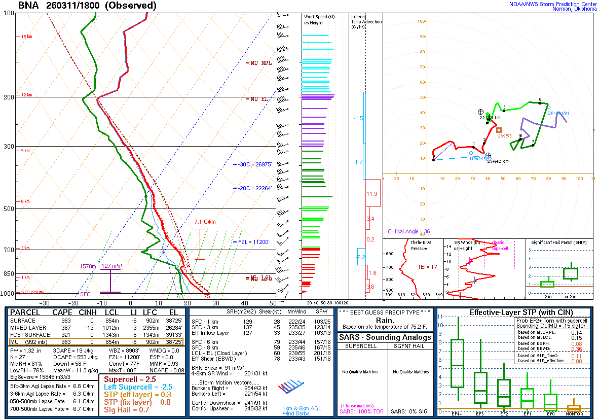
Only going to show a Nashville sounding tonight since they launched a special balloon at 1 PM. They found moderately unstable air ahead of the storms moving into their coverage area (Middle Tennessee), more so in terms of Lifted Index than surface CAPE. And the wind shear was borderline, more what you’d expect for a damaging wind event than a tornado event. Even though there was some spin in the air. It wasn’t too impressive. And the threat for supercell thunderstorms was looking low too; this was probably going to be a squall line. It did technically have a few embedded supercells, but when you see a Supercell Composite of only 2.5 units, that’s usually a reassuring sign that the severe weather isn’t going to be as big a deal as if it was at least a 5 or so.


We’ll have high pressure moving back into the region tomorrow, mostly sunny skies, a High of about 56, a Low of about 41-42. That’s for Huntsville, by the way. And we’ll have a fairly strong North breeze with gusts up to 30 mph possible. So compared to the weather lately, it’s really going to feel cold all of a sudden again.


High pressure remains in place on Friday with sunny skies and Highs in the mid/upper 60’s, Lows in the mid/upper 30’s, at least for Huntsville and surrounding areas. It will still be breezy on Friday, with gusts up to 20 mph possible. So still a pretty cool day.


Saturday looks mostly sunny with a High in the mid-70’s and Low in the lower 40’s. The winds should settle down for one day as well.


But then they will ramp up again as we’re watching a trough and Low coming out of the Midwest and aiming down this way. There is a strong and fast-moving cold front associated with this. The day Sunday looks partly to mostly sunny. But then rain looks likely Sunday night.


Monday looks cold and breezy, could see lingering isolated showers in the morning. Look for a High of about 50, a Low of about 40. Subtract about five degrees if you’re pretty close to Nashville instead of near Huntsville.


Then high pressure moves in behind that again on Tuesday. We’ll be mostly sunny with Highs in the upper 40’s and Lows in the upper 20’s for AL, lower 20’s for TN.


Then Wednesday looks partly to mostly sunny with a High near 60 and Low in the lower 30’s.


Rainfall totals will average about 1-2 inches for North Alabama and more like the range of 0.5-1 inch for Southern Middle Tennessee.


This storm system produced widespread severe weather across several states yesterday, including several tornadoes. We sort of got the leftovers around here today.
Have not heard of any injuries today. Did find two fatalities yesterday in Indiana, two people in the same manufactured home hit by a tornado. And there was an injury in Illinois, also from a tornado, report did not specify how it happened. You have to get out of a mobile home when a tornado is coming. For such a big outbreak though, that low a death count is actually considered a good outcome. I guess in a perfect world, we wouldn’t have any. But to get by with only two with such a widespread severe weather event is actually sort of encouraging . . . looking at the big picture. The warning process, and people acting on the warnings, must have worked well this time. Some of the storm chaser footage I skimmed yesterday or this morning made those tornadoes and the damage look pretty nasty, especially in Indiana. The no-injuries outcome today is even better.
FOOTNOTE:


Somehow I forgot to check this because I got so caught up in other forecast details, but the Storm Prediction Center actually did keep North Alabama in a marginal severe weather risk for some reason, for the rest of tonight. Their forecast discussion gives me no clues as to their reasoning behind this. This was issued around 8 PM tonight. I really don’t think it’s going to do anything else (severe) up here and that most of us will just get a cool rain with little or no thunder. But it’s always a good idea to go to bed with your NOAA Weather Radio on alert and Wireless Emergency Alerts enabled on your cell phone, just in case anything happens that you need to wake up for. Having said that, my personal opinion is that we have no more severe weather worries tonight. The Storm Prediction Center staff has more experience than I do. And they are keeping low-end probabilities in place. So I’d advise: Don’t let it worry you. Just go to bed with a source of weather info that would wake you up if anything did happen. And it probably isn’t going to.