
Strong Thunderstorms Possible Friday Along with Heavy Rain and Gusty Winds

NORTH ALABAMA:
(Forecast)
Thursday (High 70, Low 51): Mostly cloudy and breezy. Patchy fog is possible in the morning.
Friday (High 70, Low 62): Windy with rain and thunderstorms likely. A few thunderstorms may become severe.
Saturday (High 66, Low 60): Cloudy with lingering showers likely, mainly before Noon. Staying breezy.
(Extended Outlook)
Sunday (High 45, Low 34): Mostly sunny.
Monday (High 46, Low 25): Sunny.
Tuesday (High 52, Low 27): Sunny.
Wednesday (High 50, Low 33): Partly cloudy with a 30% chance of showers.
SOUTHERN MIDDLE TENNESSEE:
(Forecast)
Thursday (High 70, Low 50): Mostly cloudy and breezy. Patchy fog is possible in the morning.
Friday (High 69, Low 61): Windy with rain and thunderstorms likely. A few thunderstorms may become severe.
Saturday (High 64, Low 60): Cloudy with lingering showers likely, mainly before Noon. Staying breezy.
(Extended Outlook)
Sunday (High 44, Low 31): Mostly sunny.
Monday (High 45, Low 23): Sunny.
Tuesday (High 51, Low 26): Sunny.
Wednesday (High 49, Low 30): Party cloudy with a 30% chance of showers.
NORTE DE ALABAMA:
(Pronóstico)
Jueves (Máxima 70, Mínima 51): Mayormente nublado y ventoso. Posibilidad de niebla dispersa por la mañana.
Viernes (Máxima 70, Mínima 62): Ventoso con probabilidad de lluvia y tormentas eléctricas. Algunas tormentas eléctricas podrían ser fuertes.
Sábado (Máxima 66, Mínima 60): Nublado con probabilidad de lluvias intermitentes, principalmente antes del mediodía. Continuará ventoso.
(Pronóstico Extendido)
Domingo (Máxima 45, Mínima 34): Mayormente soleado.
Lunes (Máxima 46, Mínima 25): Soleado.
Martes (Máxima 52, Mínima 27): Soleado.
Miércoles (Máxima 50, Mínima 33): Parcialmente nublado con un 30% de probabilidad de lluvia.
SUR DEL CENTRO DE TENNESSEE:
(Pronóstico)
Jueves (Máxima 70, Mínima 50): Mayormente nublado y ventoso. Posibilidad de niebla dispersa por la mañana.
Viernes (Máxima 69, Mínima 61): Ventoso con probabilidad de lluvia y tormentas eléctricas. Algunas tormentas eléctricas podrían ser fuertes.
Sábado (Máxima 64, Mínima 60): Nublado con probabilidad de lluvias intermitentes, principalmente antes del mediodía. Continuará ventoso.
(Pronóstico Extendido)
Domingo (Máxima 44, Mínima 31): Mayormente soleado.
Lunes (Máxima 45, Mínima 23): Soleado.
Martes (Máxima 51, Mínima 26): Soleado.
Miércoles (Máxima 49, Mínima 30): Parcialmente nublado con un 30% de probabilidad de lluvia.
NOTES:
SKYWARN classes have been scheduled ahead of the Spring season, and after the one this evening (at the Colbert County EMA), the next one is Tuesday January 20th 6 PM at the Space and Rocket Center in Huntsville, Madison County. You know, back when I lived in the city of Huntsville, and after I moved away and had kinfolks living in or near Huntsville, I have never succeeded in getting them to attend even one of these free classes. Maybe you will have better luck, you’ve got family with more inquisitive minds. Or just go take one for yourself. That’s what I did. And now I’m confident in saying if they gave me the slides, I could easily teach one of these classes.
Saturday February 21st is Severe Weather Awareness Day at Trevecca University in Nashville. It is also free to attend, but you do have to register beforehand.
Weatherbrains recently had Greg Carbin as a guest, reviewing last year’s significant weather events (and there were quite a few, despite our quiet hurricane season for the U.S. mainland). He does that every year, and it’s always worth listening to (or watching if you prefer . . . the show is on YouTube as well as being available as just audio). And then the other night, they did a home-grown show of just the regulars discussing the severe weather warning process, what’s working well and what still needs to be improved.
DISCUSSION:
At 2 PM CST, skies are fair in Decatur. The temperature is 68 degrees. The dewpoint is 57 degrees, making the relative humidity 68%. Winds are from the South at 6 miles per hour. The pressure is 29.98 inches/1015 millibars and falling.
It is partly cloudy in Fayetteville. The temperature is 68 degrees. The dewpoint is 55 degrees, making the relative humidity 64%. Winds are Southwest at 8 mph. The pressure is 29.99 inches and steady.


We’ve had some fog this morning, and some of it is hanging around in Northwest Alabama; where you see that stuff that looks like clouds sitting still while the other stuff moves . . . that’s fog. Our upper-level winds are pretty much zonal at this point, and we’ve got a weak front trying to push its way through the region today.
The air is cool and stable with this system, might not be the case with the next one, which is our main forecast challenge this go-round.
For most places, the rest of today will be a mix of sun and clouds, a few lucky folks might get more sun than clouds, but just as many probably get clouds or even fog hanging around most of the rest of the daylight hours. Look for a High of about 69-70.


Tomorrow is an in-between day where we’ll be mostly cloudy and breezy, probably not seeing any rain. Look for a High near 70, a Low near 50 or so. Some patchy fog is possible again overnight and into tomorrow morning, not expected to be as heavy as last night’s/today’s, where it does occur.


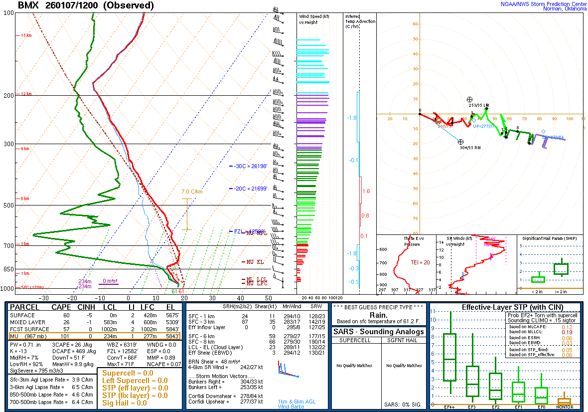
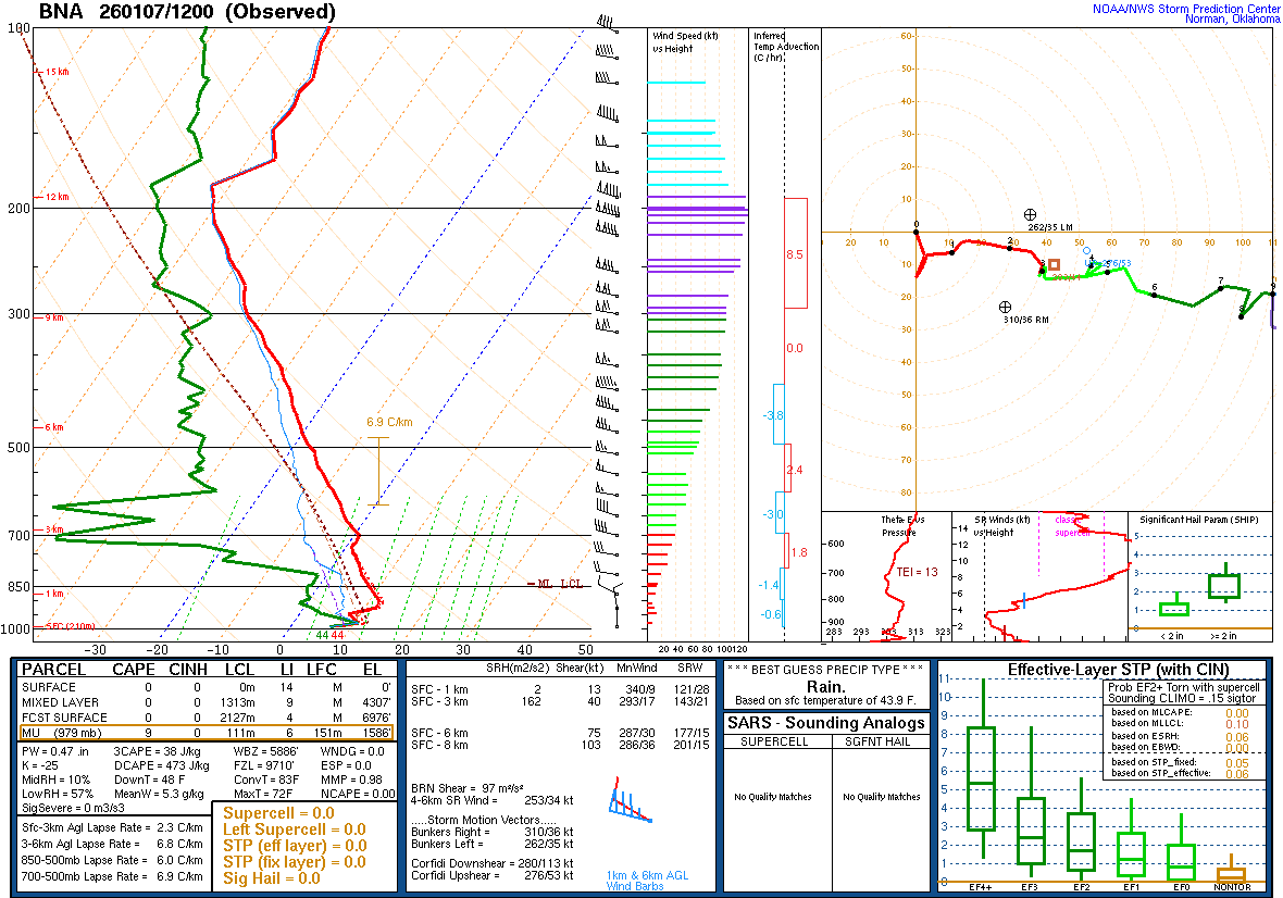
Then on Friday we have an upper-level trough approaching that is expected to take on a little bit of a negative tilt, also a surface cold front, even though the surface Low associated with it is displaced way to our North/Northeast, up across the Canadian border.
Rain and thunderstorms are likely, and the rain may become heavy at times. A few of the thunderstorms may become severe. And we’ll talk more about that below in the mesoscale discussion. Look for a High near 70, a Low of about 62.


And even the GFS, which usually wants to move systems along faster than the other models, has come on board with the idea that this front will continue moving slowly through our region on Saturday. At least through Noon, showers are still likely across the TN Valley. Look for a High in the mid-60’s and a Low near 60. It’ll still be breezy at times, with winds shifting around to the West and then Northwest as the front progresses through the region.


The seriously cold air comes back for Sunday, mostly sunny skies, a High near 45 and a Low of only about 35, mid-30’s. And actually on the TN side, Highs should stay more in the lower 40’s with Lows down close to 30, more in the 30-32 range.


Monday looks sunny as high pressure overtakes the region again, a High in the mid-40’s and a Low in the mid-20’s on the AL side, lower 20’s for TN side.


Then Tuesday also looks sunny with a High in the lower 50’s and Low in the upper 20’s. Some places on AL side may approach 30 again, but that’s as much rebound of temperatures as you can expect.


The models are in fair agreement about another system coming our way next Wednesday, the 14th. But a lot of details will need to be ironed out over the next several days. As of right now, the most sensible forecast is a 30% chance of rain and a High near 50, Low in the lower 30’s.


Rainfall totals may average in the 2-4 inch range for this forecast period, and there is a slight risk of some flooding issues for our area between Friday and Saturday.
