
Severe Thunderstorms Possible Going into Tomorrow/Tomorrow Night

NORTH ALABAMA:
(Forecast)
Wednesday (High 75, Low 63): Thunderstorms likely. Some storms may be severe.
Thursday (High 69, Low 57): Gradual clearing, becoming partly to mostly sunny. Isolated showers may linger in the morning.
Friday (High 73, Low 47): Mostly sunny. Mild.
(Extended Outlook)
Saturday (High 80, Low 52): Mostly sunny.
Sunday (High 78, Low 60): Thunderstorms likely.
Monday (High 74, Low 59): Mostly sunny with a 20% chance of showers.
Tuesday (High 75, Low 50): Sunny.
SOUTHERN MIDDLE TENNESSEE:
(Forecast)
Wednesday (High 72, Low 61): Showers and thunderstorms likely. A few storms may become severe.
Thursday (High 66, Low 53): Gradual clearing, becoming mostly sunny. Isolated showers may linger in the morning.
Friday (High 72, Low 44): Sunny. Mild.
(Extended Outlook)
Saturday (High 79, Low 50): Mostly sunny.
Sunday (High 76, Low 60): Thunderstorms likely.
Monday (High 72, Low 58): Mostly sunny with a 20% chance of showers.
Tuesday (High 74, Low 48): Sunny.
NORTE DE ALABAMA:
(Pronóstico)
Miércoles (Máxima 75, Mínima 63): Probabilidad de tormentas eléctricas. Algunas tormentas podrían ser severas.
Jueves (Máxima 69, Mínima 57): Despeje gradual; pasará a estar parcialmente nublado o mayormente soleado. Podrían persistir lluvias aisladas durante la mañana.
Viernes (Máxima 73, Mínima 47): Mayormente soleado. Templado.
(Pronóstico Extendido)
Sábado (Máxima 80, Mínima 52): Mayormente soleado.
Domingo (Máxima 78, Mínima 60): Probabilidad de tormentas eléctricas.
Lunes (Máxima 74, Mínima 59): Mayormente soleado, con un 20% de probabilidad de lluvias.
Martes (Máxima 75, Mínima 50): Soleado.
SUR DEL CENTRO DE TENNESSEE:
(Pronóstico)
Miércoles (Máxima 72, Mínima 61): Probabilidad de lluvias y tormentas eléctricas. Algunas tormentas podrían volverse severas.
Jueves (Máxima 66, Mínima 53): Despeje gradual; pasará a estar mayormente soleado. Podrían persistir lluvias aisladas durante la mañana.
Viernes (Máxima 72, Mínima 44): Soleado. Templado.
(Pronóstico Extendido)
Sábado (Máxima 79, Mínima 50): Mayormente soleado.
Domingo (Máxima 76, Mínima 60): Probabilidad de tormentas eléctricas.
Lunes (Máxima 72, Mínima 58): Mayormente soleado, con un 20% de probabilidad de lluvias.
Martes (Máxima 74, Mínima 48): Soleado.
NOTES:
It is a good time to review your safety weather safety plan and make sure everybody in your family understands it, in case you need it tonight or more likely tomorrow/tomorrow night.
The University of Iowa has an interactive map showing the storm reports from April 27-29 this past week.
The National Weather Service in Nashville continues its online Weather101 classes through the rest of this month.
DISCUSSION:


At 2 PM CDT, skies are mostly cloudy in Huntsville. The temperature is 74 degrees. The dewpoint is 50 degrees, making the relative humidity 43%. Winds are from the South at 8 miles per hour, with higher gusts up to 18 mph. The pressure is 29.93 inches/1013 millibars and falling.
It is sunny and 66 degrees in Columbia. The dewpoint is 55, making the relative humidity 68%. Winds are South at 12 mph, with gusts up to 20. The pressure is 29.82 inches and falling.
Our upper-level winds are turning more to the West/Southwest as our next cold front approaches the region. And we already have some showers ahead of it, even into North Alabama. What we’re getting today is just beneficial rain, not really seeing any lightning with it at this point. Clouds are definitely starting to overspread the region, especially our Tennessee counties.
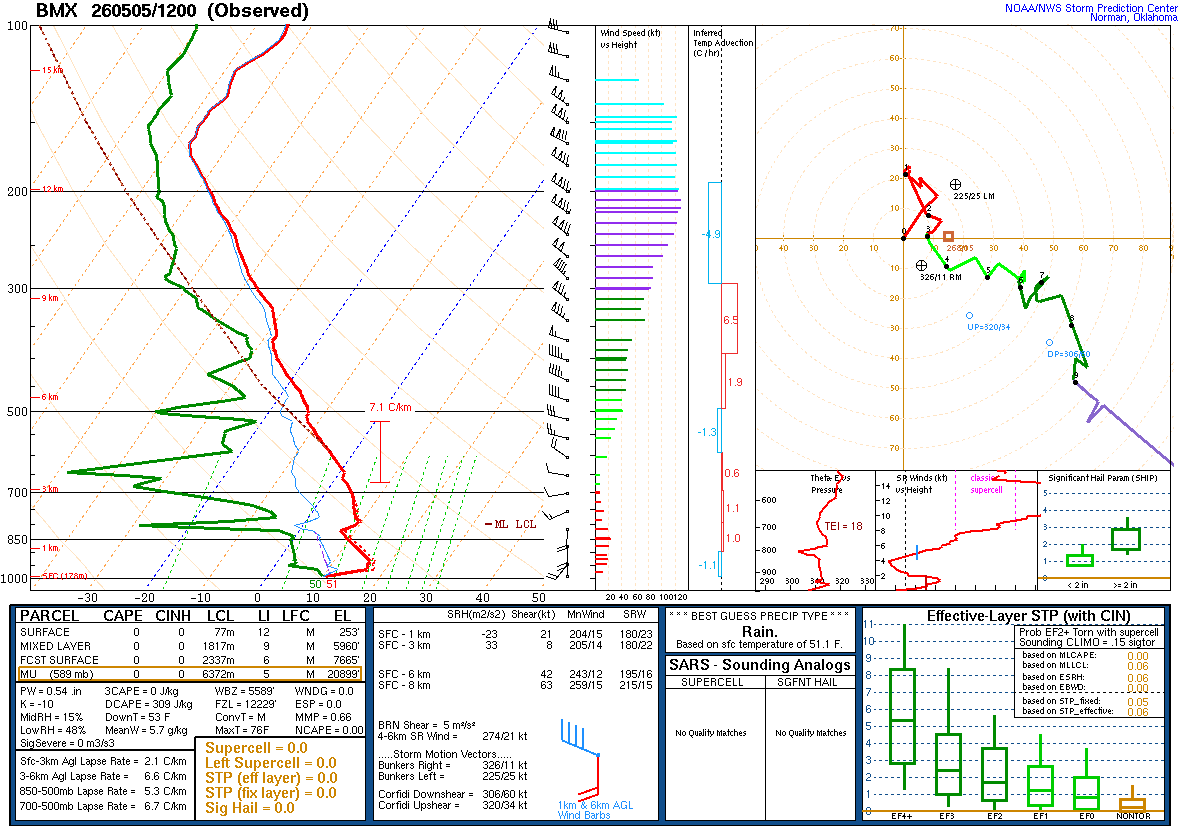
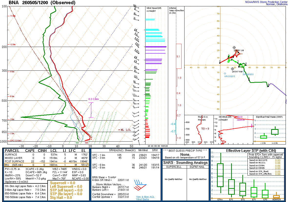
This morning’s upper-air soundings showed a stable airmass. Some wind shear was trying to get going in Nashville.


That cold front is going to be our weathermaker over the next couple days.


The Storm Prediction Center has introduced a Marginal Level 1/5 Risk for severe thunderstorms including the Shoals and places like Lawrenceburg and Pulaski in Tennessee. This outlook runs not only through late tonight but into the early morning hours tomorrow, technically extends until 7 AM tomorrow morning.


Showers and thunderstorms are likely tomorrow, and we’ll have to watch for the potential of severe thunderstorms. The High will range from about 70-75, with warmer temperatures on the Alabama side, Lows in the lower-to-mid-60’s.


The high-res NAM is showing moderately to strongly unstable air moving through the Tennessee Valley, mainly Northern Alabama, during the peak heating hours, between 1 and 7 PM tomorrow.


And unfortunately it is also showing ample amounts of the kind of wind shear we watch for tornado potential, even at the lowest level of the atmosphere.


And actually by the time we get to 7 PM the Significant Tornado Parameter values look concerning for places like Cullman, Morgan, Marshall, Blount, Etowah, and Walker Counties.
All of us should have an isolated tornado threat, but if this guidance is right, the threat could be enhanced just after sundown for that general area I just mentioned.


The HRRR shows a much lower-end isolated tornado threat at that same time frame. And it’s the CAM a lot of storm chasers seem to swear by these days. The high-res NAM (as well as the standard NAM) can get carried away sometimes.


The SREF tends to be more balanced than the CAM’s, but even it is showing an elevated tornado threat (most likely for Northeast Alabama) with more of an overnight event tomorrow night into early Thursday morning, the wee hours.
So we’ll see how this plays out. It looks like a messy storm mode with several rounds of storms possible through tomorrow. At some point in the evening or night hours, the main squall line is expected to get here. Even storms within the squall line look like they may have a fair chance of spinning up a tornado along with the more standard threat for damaging thunderstorm winds and large hail.


The Storm Prediction Center has outlooked most of North Alabama for a Slight Level 2/5 Risk of severe thunderstorms tomorrow/tomorrow night. A Marginal Level 1/5 Risk is in effect for Southern Middle Tennessee. Also note that an Enhanced Level 3/5 Risk covers areas just to our South and clips parts of Walker and Blount Counties.
This is mainly a damaging wind threat, could also see some large hail in storms, especially in Northwest Alabama. But the tornado threat is nothing to sneeze at with this one, especially along and South of the Tennessee River. Some low-end potential for an isolated tornado even extends into our bordering counties in Southern Middle Tennessee. Up closer to Nashville, the threat for even damaging straight-line winds is marginal.


The latest model guidance makes it look like we’ll be clearing out Thursday morning.
Will keep in a 20% chance of showers in the morning hours. Highs should be in the upper 60’s and Lows in the 50’s.


With the front down along the Gulf Coast on Friday, we’ll be mostly sunny with a High in the lower 70’s and Low down in the 40’s.


Saturday also looks mostly sunny with high pressure centered up in Kentucky. High temperatures around here should be near 80, Lows around 50 or so, lower 50’s.


The GFS shows another system moving through here with a lot of rain on Sunday. And this would be another one to watch for severe weather potential if this guidance were to be right. The surface Low is tracking in a favorable synoptic position for that.
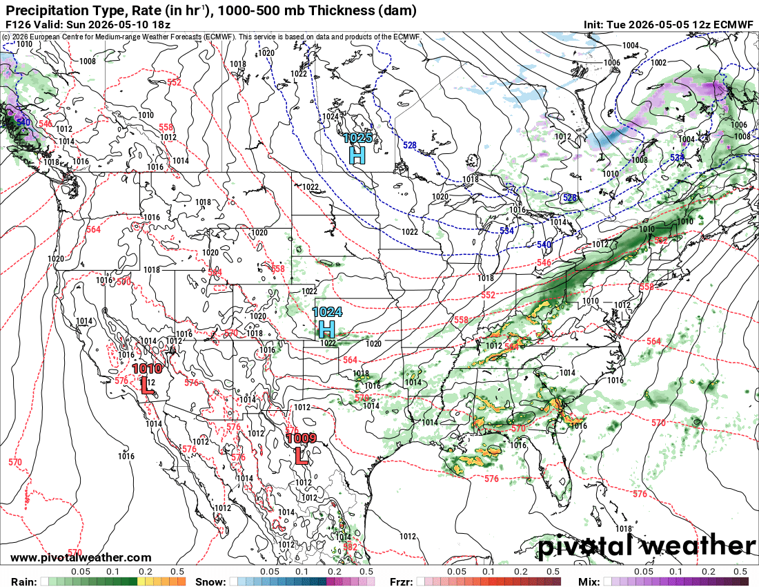
The ECMWF does not make the system look as impressive, but we’ll keep an eye on it.
Before speculating on rain chances and temperatures, going to take a look at next Monday.


And the two main global models keep us dry Monday on this latest run.
So forecasting likely showers and thunderstorms Sunday, will keep an eye on severe potential, with a High in the upper 70’s or near 80, Low in upper 50’s or near 60.
Then Monday, mostly sunny with a 20% chance of showers to account for the morning. Highs in lower-to-mid-70’s and Lows near 60 or upper 50’s.


Then Northwest flow aloft and strong High pressure at the surface on next Tuesday should make for sunny conditions and a High in the lower-to-mid-70’s, a Low near 50, maybe upper 40’s on TN side.


Peeking out to 10 days, it is looking to stay dry through Friday as we get to mid-month. And things often do start settling down in mid-May. But technically the entire month is considered the end of our main severe weather season around here. Once we get into June, the summer pattern is usually starting to get pretty well-established. This upper-level pattern looks like a split flow where things could get active again. They just don’t look that way the 13th through 15th based on current guidance. And by this time hopefully we’ll have gotten plenty of that rain we so need before Summer hits in earnest.
This looks like Highs in lower 80’s and Lows of about 60 or so with little if any rain chances for Days 8-10, maybe a 20% chance again by Friday.
And that’s not going into an official forecast up top, just a bonus for those of you who bother to read the discussion.


We could easily see 2-3 inches of rainfall totals over the next week. There is a slight risk for flash flooding across North Alabama. Then that risk becomes more marginal as you get into Tennessee. And that’s for tomorrow/tomorrow night.
We do have a very low chance of isolated severe thunderstorms making it into at least Northwest Alabama and adjacent parts of Southern Middle Tennessee late tonight into the very early hours of tomorrow morning. So have a reliable way to get warnings that will wake you up, a weather radio or WEA, not just relying on an outdoor siren.


But the main threat is tomorrow afternoon and evening for Southern Middle Tennessee, and evening through about Midnight or so for North Alabama.
The main threat is damaging thunderstorm winds, but we could easily see some severe hail and isolated tornadoes in the region as well. Most of the storms will probably come with the squall line in the evening through night hours. Even though the main threat is damaging straight-line winds, be prepared for a tornado. Somebody could easily get one out of this setup, even if the risk is relatively low for any one spot.