


Seasonal Summer Heat, Rain Mostly Staying Widely Scattered for the New Week

FORECAST:
Sunday (High 92, Low 69): Mostly sunny. An isolated shower or thunderstorm is possible.
Monday (High 93, Low 70): Mostly sunny. Isolated showers and thunderstorms are possible.
Tuesday (High 91, Low 71): Partly cloudy. Widely scattered showers and thunderstorms are possible.
EXTENDED OUTLOOK:
Wednesday (High 90, Low 70): Partly cloudy with a 30% chance of showers/thunderstorms.
Thursday (High 89, Low 70): Partly cloudy with a 40% chance of showers/thunderstorms.
Friday (High 87, Low 72): Mostly cloudy with a 50% chance of showers/thunderstorms.
Saturday (High 88, Low 69): Partly cloudy with a 40% chance of showers/thunderstorms.
BEACH FORECAST:
Sunday (High 91, Low 74): Mostly sunny. Isolated showers and thunderstorms are possible.
Monday (High 90, Low 75): Partly cloudy. Scattered showers and thunderstorms are possible.
Tuesday (High 90, Low 75): Partly cloudy. Widely scattered showers and thunderstorms are possible.
Wednesday through Saturday (Highs ~90, Lows ~75): Partly to mostly cloudy with a 50% chance of showers/thunderstorms.
PRONÓSTICO:
Domingo (Máxima 92, Mínima 69): Mayormente soleado. Posibles lluvias o tormentas aisladas.
Lunes (Máxima 93, Mínima 70): Mayormente soleado. Posibles lluvias y tormentas aisladas.
Martes (Máxima 91, Mínima 71): Parcialmente nublado. Posibles lluvias y tormentas muy dispersas.
PERSPECTIVA EXTENDIDA:
Miércoles (Máxima 90, Mínima 70): Parcialmente nublado con un 30 % de probabilidad de lluvias o tormentas.
Jueves (Máxima 89, Mínima 70): Parcialmente nublado con un 40 % de probabilidad de lluvias o tormentas.
Viernes (Máxima 87, Mínima 72): Mayormente nublado con un 50 % de probabilidad de lluvias o tormentas.
Sábado (Máxima 88, Mínima 69): Parcialmente nublado con un 40 % de probabilidad de lluvias o tormentas.
PRONÓSTICO DE LA PLAYA:
Domingo (Máxima 91, Mínima 74): Mayormente soleado. Posibles lluvias y tormentas aisladas.
Lunes (Máxima 90, Mínima 75): Parcialmente nublado. Posibles lluvias y tormentas dispersas.
Martes (Máxima 90, Mínima 75): Parcialmente nublado. Posibles lluvias y tormentas muy dispersas.
Miércoles a Sábado (Máxima ~90, Mínima ~75): Parcialmente a mayormente nublado con un 50 % de probabilidad de lluvias/tormentas.
NOTES:
This hurricane season is expected to be above average due to warm ocean temperatures.
Here are some rules for staying safe in rip currents.
NOAA has an animated series to teach kids about weather and climate.
Although it’s been a few weeks, I’d still encourage anyone to go and listen to the Weatherbrains interview with Max Velocity. Or better yet, follow his YouTube channel or website (linked under “Useful Resources” on the left-hand side of the desktop version of my website).
DISCUSSION:
It was a mostly sunny day in Cullman with a period of light rain and haze. The High was 91, and the Low was 72. Jasper saw a few more clouds today, more fog this morning, a High of 93 and a Low of 70. Huntsville had a High of 94 and Low of 73. And Nashville saw a few more clouds from time to time, but still had a High of 95 and Low of 73.


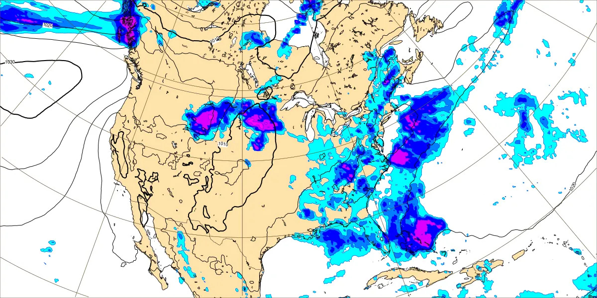
Even isolated rain has been hard to find today, as we’re under a ridge of high pressure. We do have Tropical Storm Chantal off the coast of the Carolinas. A little of its moisture is able to wrap around in our direction, but not much. And our winds aloft are northerly at the moment, instead of southerly from the Gulf, like you’d expect in early July.
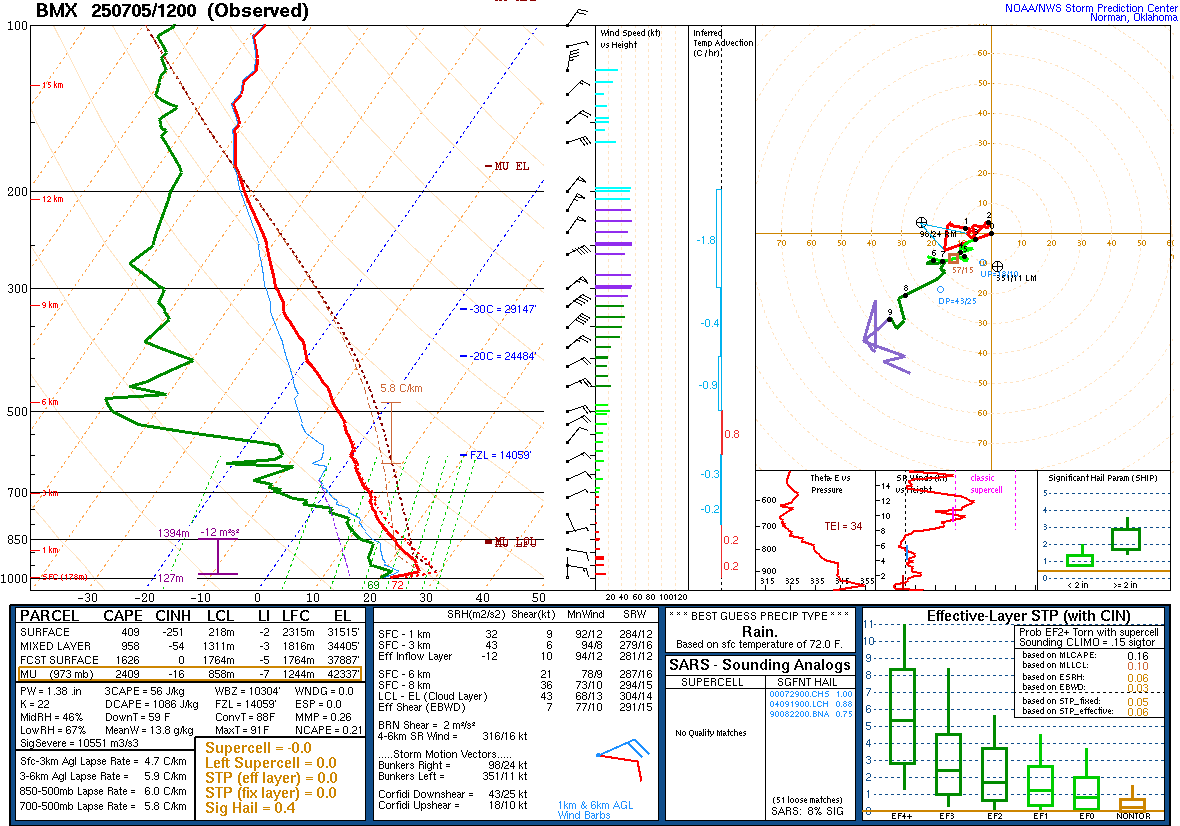


The upper-air soundings from 7 AM this morning at Birmingham, Nashville, and Jackson show a pretty typical summer airmass overall but a little less humidity than we’d typically have at the beginning of July, first week of July.


Tomorrow looks much the same. Tropical Storm Chantal will likely make landfall between South Santee River, South Carolina and Surf City, North Carolina. (Didn’t they make a song about that place?) Around here we’ll be mostly sunny with only a minimal 20% chance of rain, look for a High near 92, Low near 69.


Basically the same setup for Monday, will only include a 20% chance of rain, but do notice that our upper-level winds are shifting back around to the South. Look for a High of about 92-93, Low near 70.


Moisture levels will increase slightly on Tuesday so that a rain chance of 30% is more reasonable. Highs should be about 90 or so, Lows about 70 or so, High in about the 90-92 range.


Will hold that rain chance for Wednesday, 30%, with a High near 90, Low near 70.


Thursday a weak frontal boundary will be trying to move into the region, not too impressed with how much it’s going to do. But moisture levels will rise enough to justify a 40% chance of rain. Look for a High in the upper 80’s, a Low of 70 or so, lower 70’s.


Then on Friday the GFS is showing a significant increase in moisture across the region.
Since the European model is on board with this, and the models have done better than expected so far this Summer, going to take this trend seriously and bump rain chances up to 50% for Friday. Look for a High in the mid-to-upper 80’s and a Low near 70, could dip into upper 60’s due to rain-cooled air, delicate balance sometimes there. With humidity making the temperatures warmer at night versus some rain-cooled air if we get enough of those showers. Which we might Friday/Friday night if these trends verify.


Then for next Saturday, it’s iffy whether that boundary passes through the region or just sort of washes out . . . probably the latter. That’s how things usually go in July. But will maintain a 40% chance of scattered rain, Highs in the upper 80’s and Lows near 70 or at least in the upper 60’s.


Tropical Storm Chantal has formed and is located at 31.9 degrees North Latitude, 78.7 degrees West of longitude, basically off the coast of the Carolinas. Maximum sustained winds are at 45 mph. It is currently moving due North at 7 mph. It is expected to strengthen only slightly before reaching the coast (probably of South Carolina) overnight or in the morning, after which it will start to weaken. It is expected to turn a little more Northwest before landfall and then Northeast after landfall. Besides heavy rains and tropical storm force winds, it is creating really hazardous surf conditions/rip currents in that area.
There are some disturbances South of Mexico that are not named storms yet, but I don’t really spend time on stuff that far away unless our local tropics (in the Atlantic or the Gulf) are really quiet. Which they are not right now. We’ve got a tropical storm on the board. So that gets priority.

Our local rainfall totals over the next week will probably average about one inch. The really heavy totals of 2-3 inches or greater will likely occur along the Carolina coastlines, maybe the Virginia coast as well. Tropical cyclones are about the only way to get widespread heavy rain this time of year.