


Mainly Seasonal Heat and Humidity, Rain Will Stay Scattered at Best

FORECAST:
Sunday (High 90, Low 71): Partly cloudy. Widely scattered showers and thunderstorms are possible.
Monday (High 92, Low 71): Partly to mostly sunny. Isolated showers and thunderstorms are possible.
Tuesday (High 94, Low 72): Partly to mostly sunny. Isolated showers and thunderstorms are possible.
EXTENDED OUTLOOK:
Wednesday (High 93, Low 73): Partly cloudy with a 30% chance of showers/thunderstorms.
Thursday (High 91, Low 73): Mostly cloudy with a 50% chance of showers/thunderstorms.
Friday (High 89, Low 72): Partly to mostly cloudy with a 40% chance of showers/thunderstorms.
Saturday (High 91, Low 71): Partly cloudy with a 30% chance of showers/thunderstorms.
BEACH FORECAST:
Sunday (High 90, Low 78): Mostly sunny with an isolated shower or thunderstorm possible.
Monday (High 92, Low 78): Mostly sunny with an isolated shower or thunderstorm possible.
Tuesday (High 94, Low 79): Mostly sunny with an isolated shower or thunderstorm possible.
PRONÓSTICO:
Domingo (Máxima 90, Mínima 71): Parcialmente nublado. Posibles lluvias y tormentas eléctricas muy dispersas.
Lunes (Máxima 92, Mínima 71): Parcialmente a mayormente soleado. Posibles lluvias y tormentas eléctricas aisladas.
Martes (Máxima 94, Mínima 72): Parcialmente a mayormente soleado. Posibles lluvias y tormentas eléctricas aisladas.
PERSPECTIVA EXTENDIDA:
Miércoles (Máxima 93, Mínima 73): Parcialmente nublado con un 30 % de probabilidad de lluvias/tormentas eléctricas.
Jueves (Máxima 91, Mínima 73): Mayormente nublado con un 50 % de probabilidad de lluvias/tormentas eléctricas.
Viernes (Máxima 89, Mínima 72): Parcialmente nublado con un 40 % de probabilidad de lluvias/tormentas eléctricas.
Sábado (Máxima 91, Mínima 71): Parcialmente nublado con un 30 % de probabilidad de lluvias o tormentas eléctricas.
PRONÓSTICO DE LA PLAYA:
Domingo (Máxima 90, Mínima 78): Mayormente soleado con posible lluvia o tormenta eléctrica aislada.
Lunes (Máxima 92, Mínima 78): Mayormente soleado con posible lluvia o tormenta eléctrica aislada.
Martes (Máxima 94, Mínima 79): Mayormente soleado con posible lluvia o tormenta eléctrica aislada.
NOTES:
The Weatherbrains podcast did the best commentary I’ve seen or heard on the recent catastrophic flood event in Texas.
The Amber Alert from Thursday was cancelled Friday morning as the child was found safely and the abductor arrested.
Tomorrow will be the six-year anniversary of Hurricane Barry.
DISCUSSION:


We had a mostly sunny day in Cullman with a brief period of light rain. The High was 90, and the Low was 72. Jasper saw a mix of sun and clouds today and a pretty good thunderstorm this afternoon, High of 91, Low of 70. Haleyville also got that thunderstorm cluster, but most of the day was seeing more sun than clouds, had a High of 87 and Low of 70.
Decatur had a High of 90 and Low of 73. Huntsville had a High of 94 and Low of 73. Muscle Shoals saw a High of 94 and Low of 73. Tupelo had a High of 92 and Low of 71. Memphis saw a High of 91 and Low of 74. Nashville actually has a thunderstorm moving through right now at the 10 o’ clock hour. Overall they had a partly cloudy day with a High of 93 and Low of 74.
And we remain under a typical summer ridge that is keeping all the really active, organized thunderstorms along a cold front up to our North, mainly in the Ohio River Valley. We have surface High pressure in place over the Southeast region and Tennessee Valley, and our only rain is coming from Gulf moisture and/or mesoscale boundaries from day to day. This happens every July. The heat and humidity can be rough if you get caught out taking a pretty good walk in the hottest times of day, but we’re near seasonal averages. I can think of several July’s that were worse than what we’re having now, much worse. This is just the kind of heat and humidity we’d expect.


This evening’s radiosonde soundings from Birmingham and Nashville showed a powder keg of unstable air, with CAPE values over 2,000 joules/kilogram and Lifted Indices all the way down to -7. But with little to no wind shear, all we get are these random summer thunderstorms like the one moving through Nashville at this hour, not the organized severe weather we’d see in the springtime if there was more wind shear and a more dynamic atmospheric setup.


Tomorrow looks like a partly cloudy day with a 30% chance of showers and thunderstorms. The High should be about 90, and the Low should be about 70-72 again.


For Monday, will trim the rain chance back to 20% and forecast a High of about 91-92, Low near 70 or so.


Then on Tuesday, will keep the rain chance at 20% and forecast a High more like 92-94 range, Low about 70-73 range.


On Wednesday, will believe the model trends in increasing moisture again slightly and bring rain chance back to 30%. Look for a High in the lower 90’s, Low in the lower 70’s.


Thursday the models show a noticeable increase in moisture over our region, and I think this may come from a mesoscale convective system that passes to our North but then drifts Southwest back down the Appalachian mountains, those clusters of storms. Will bring rain chance up to 50%, High of 90 or so, Low near 70.


By Friday it looks like a strong heat bubble of High pressure is retrograding from the Atlantic into our region. And we’ll have to watch for excessive heat problems if this scenario plays out. Look for a rain chance of 40% Friday and a High temperature in the upper 80’s, Low of 70 or so.


By Saturday I think we’ll see temperatures rise again with only a 30% chance of rain, look for a High of 90 or so, Low still hovering around 70 or so.
And beyond that, we’ll have to watch if that strong upper-level High can maintain itself across our region. Because if it does, we could get some serious July heat cooking up. As of right now, there’s no reason to be overly alarmed about a scenario like that.

A trough of low pressure is expected to form in the Gulf and maybe bring some heavy rains to parts of the Gulf Coast by about Tuesday. This might be what the models were picking up on for the latter half of next week for us further North. Even so, the chance of this becoming a tropical cyclone within the next week is low, about 20%.


More flooding risk going on for Texas when they haven’t even finished relief efforts from the historic flooding they recently had.
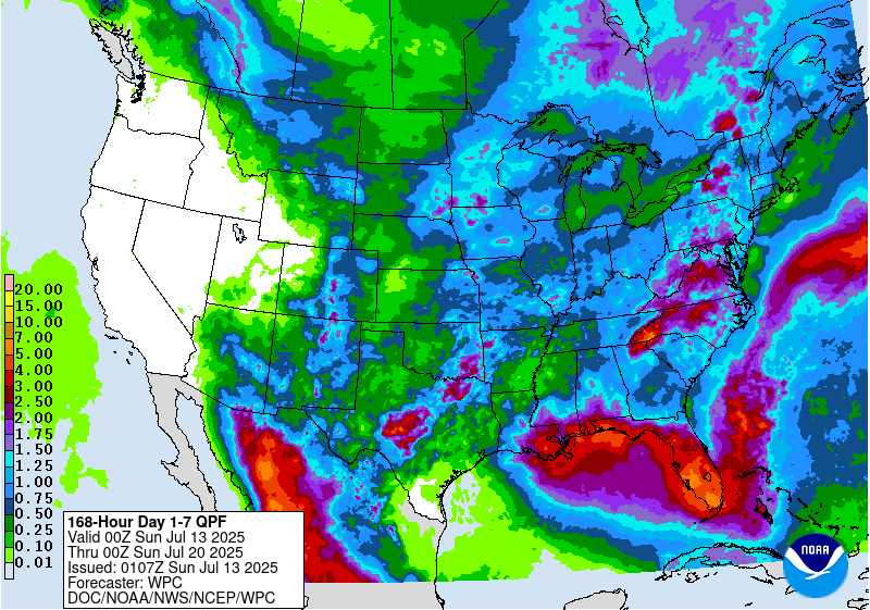
Our rainfall totals over the next week locally will average about half an inch or less. Higher amounts up to 3 inches or so are possible down at the coast and into Florida.