
Fire Weather Watch

URGENT - FIRE WEATHER MESSAGE
National Weather Service Huntsville AL
1052 AM CDT Sat Apr 11 2026
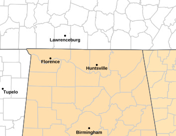
...Fire Weather Watch in Effect Sunday 11 AM until 7 PM For All
of North Alabama...
ALZ001>010-014-016-120300-
/O.NEW.KHUN.FW.A.0002.260412T1600Z-260413T0000Z/
Lauderdale-Colbert-Franklin AL-Lawrence-Limestone-Madison-Morgan-
Marshall-Jackson-DeKalb-Winston-Cullman-
1052 AM CDT Sat Apr 11 2026
...FIRE WEATHER WATCH IN EFFECT FROM SUNDAY AFTERNOON THROUGH
SUNDAY EVENING FOR ALL OF NORTH ALABAMA FOR DRY CONDITIONS AND
ELEVATED WINDS...
* AFFECTED AREA...Fire Weather Zone 001 Lauderdale, Fire Weather
Zone 002 Colbert, Fire Weather Zone 003 Franklin AL, Fire
Weather Zone 004 Lawrence, Fire Weather Zone 005 Limestone,
Fire Weather Zone 006 Madison, Fire Weather Zone 007 Morgan,
Fire Weather Zone 008 Marshall, Fire Weather Zone 009 Jackson,
Fire Weather Zone 010 DeKalb, Fire Weather Zone 014 Winston
and Fire Weather Zone 016 Cullman.
* TIMING...11 AM through 7 PM Sunday
* WINDS...Sustained south winds around 10 mph with gusts to
between 15-20 mph.
* RELATIVE HUMIDITY...As low as 29 percent.
* TEMPERATURES...In the lower to mid 80s.
* IMPACTS...Any fires that develop will likely spread rapidly.
Please obey any local burn bans that are in place!
PRECAUTIONARY/PREPAREDNESS ACTIONS...
A Fire Weather Watch means that critical fire weather conditions
are forecast to occur. Listen for later forecasts and possible
Red Flag Warnings.
&&
$$
URGENT - FIRE WEATHER MESSAGE
National Weather Service Birmingham AL
1057 AM CDT Sat Apr 11 2026
...FIRE POTENTIAL INCREASES SUNDAY AFTERNOON...
Drought and dry conditions remain across the area. Winds will
increase across the north on Sunday, increasing the potential for
fires to increase during the day.
ALZ011>013-015-017>029-120600-
/O.NEW.KBMX.FW.A.0002.260412T1600Z-260413T0000Z/
Marion-Lamar-Fayette-Walker-Blount-Etowah-Calhoun-Cherokee-
Cleburne-Pickens-Tuscaloosa-Jefferson-Shelby-St. Clair-Talladega-
Clay-Randolph-
1057 AM CDT Sat Apr 11 2026
...FIRE WEATHER WATCH IN EFFECT FROM SUNDAY MORNING THROUGH
SUNDAY EVENING ACROSS THE NORTHERN HALF OF THE AREA...
The National Weather Service in Birmingham has issued a Fire Weather
Watch for an increase in fire potential, which is in effect from
Sunday afternoon through Sunday evening.
* WINDS...South 10 to 15 mph. Gusts may be as high as 20 mph.
* RELATIVE HUMIDITY...As low as 24 percent.
* IMPACTS...The combination of a dry air mass and windy
conditions will result in critical fire weather conditions.
Outdoor burning is not recommended.
PRECAUTIONARY/PREPAREDNESS ACTIONS...
A Fire Weather Watch means that critical fire weather conditions
are forecast to occur. Listen for later forecasts and possible
Red Flag Warnings.
&&
$$